Home › Sa Pa › Ham Rong, Ta Phin, QL.4D.Sa Pa, rice fields (24301)

Ham Rong, Ta Phin, QL.4D.Sa Pa, rice fields (24301) through time

Sa Pa 2025 2 photos of this spot

2 recent photographs taken at the same spot in Sa Pa, spanning 2025. Have an older picture of it? Add it and start this spot's timeline.

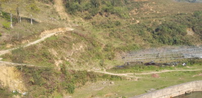
Rice fields near Ta Phin, along route QL.4D outside Sa Pa in northern Vietnam, photographed in 2025. Terraced rice cultivation on the steep slopes around Sa Pa is a defining feature of the local landscape and economy.

See this spot on the map
Have an old photo of Ham Rong, Ta Phin, QL.4D.Sa Pa, rice fields (24301)? A family album, a postcard, a print from the attic. Pin it to the map and it becomes part of the record.
Add your photo

Ham Rong, Ta Phin, QL.4D.Sa Pa, rice fields (31952), Sa Pa, 2025
Ham Rong, Ta Phin, QL.4D.Sa Pa, rice fields (31952) 2025 Rice fields near Ta Phin, along route QL.4D outside Sa Pa in northern Vietnam, photographed in 2025. Terraced rice cultivation on the steep slopes around Sa Pa is a defining feature of the local landscape and economy.
Ham Rong, Ta Phin, QL.4D.Sa Pa, rice fields (24301), Sa Pa, 2025
Ham Rong, Ta Phin, QL.4D.Sa Pa, rice fields (24301) 2025 Terraced rice fields near Ta Phin, in the hills below Ham Rong ('Dragon's Jaw') mountain above Sa Pa, are farmed by the ethnic minority communities of Vietnam's northern highlands.